
 On May 14, 2008, the Colorado Geological Survey (CGS) was contacted about a significant landslide event on US Forest Service property in Archuleta County. The slide is named the East Fork Slide, in reference to its location 2 miles up the East Fork of the San Juan River from the point where it joins the West Fork along US Hwy 160. This location is 12 miles northeast (upstream) from Pagosa Springs.
The active slide comprised about 35 acres, but was just one within a larger complex of older earthflow-type landslides on the hill covering approximately 350 acres. The older landslide goes uphill toward a 300 ft high head scarp of volcanic bedrock. The toe of the active landslide was pinching the East Fork of the San Juan River, creating the possibility of blocking the river channel for up to 600 ft in length. After reviewing all of the data it seemed clear that this partial reactivation of an older, large landslide complex was a threat to the East Fork of the San Juan River.
Additional road damage occurred east of the slide area where a smaller slide caused a loss of 75% of the width of the roadway west of the Silver Falls Guard Station.
The slide area covers about 40 acres: 3,500 feet top to bottom and 600 feet wide. The road which once crossed the slide area slid about 100 feet down the hillside. The stability of the route across the slide is uncertain. The slide is not currently moving, however with changing conditions it could move again and is expected to move next spring.
Those entering the slide area are reminded to be cautious. There are many leaning trees and large cracks in the ground (up to 3 feet in width and 6 feet in depth). The most hazardous of the cracks are those that are narrow and covered by grass.
For more information, contact Becca Smith at Pagosa Ranger District, by calling 970 264-2268.
More information;
It will take a lot of work to put this back like it was.
It is hard to realize the mountain side has moved down so far. The old road bed is now a hundred or so feet lower than it was. The slide is deep and the trees and foliage are moving also. There are major cracks in the earth all along the path that is 3,500 feet long and 600 feet wide.
Workmen cut a new path where the road was, for the pipe to lay on. It was fortunate the gas pipe broke at a time when gas need is low. Workmen put in a temporary four inch pipe replacing the normal eight inch one. This steel pipe rests on wood beams placed cross wise so the earth and beam can move under it. When the earth moves too far workmen have to readjust the beams.
The pipe slides on the wood as the earth moves.
Piles of trees lay in the area and many more trees are still in the ground but tilting at odd angles. Many will not survive having been ripped away from their roots.
We tend to think of these mountains as solid and still but an event like this reminds that they are in continuous evolution. Many millions of years ago there was several thousand feet of volcanic rock material laying on the surface we know today. It all eroded into rivers and was carried away.
See link below to this site for more information.
700 years ago a similar slide filled the lower valley and formed Lake San Christabol outside of Lake City, Colorado. A drive into Lake City is interesting as one actually drives across it on Slumgullion Pass. Many whalers changed professions and worked as miners in the 1800’s. They named the slide area Slumgullion after a stew of the same name made from whale blubber on whaling ships. The slide area is yellowish and clumpy much like blubber.
The East Fork slide is an on-going geologic event. No one can say when it might stop. If it develops into a much larger slide could we see a beautiful new lake in Pagosa Country?
East Fork Landslide Report May 18, 2008
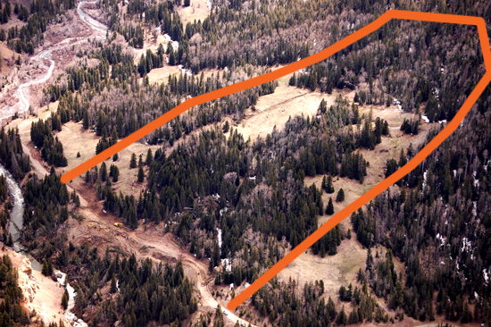
On May 14, 2008, the Colorado Geological Survey (CGS) was contacted about a significant landslide event on US Forest Service property in Archuleta County. The slide is named the East Fork Slide, in reference to its location 2 miles up the East Fork of the San Juan River from the point where it joins the West Fork along US Hwy 160. This location is 12 miles northeast from Pagosa Springs. CGS geologist Chris Carroll, who was working in Pagosa Springs area, was sent to respond to the initial call from the Archuleta County Office of Emergency Management (OEM). At their request, Mr. Carroll and one of the OEM coordinators boarded a Civil Air Patrol plane to fly the landslide-affected area. Due to the constricted nature of the box canyon of the East Fork Valley the plane could only fly within 1,000 ft of the ground. Over 100 photographs of the East Fork landslide (Figure 1), the downstream floodplain toward Pagosa, and the nearby Jackson Mountain Landslide were collected.
Figure 1. Eastward looking view of the East Fork Landslide showing the Forest Service Road, Excel Energy pipeline right-of-way, and the constriction of the river.
At 3:00 PM OEM held a conference of pertinent emergency personnel for Archuleta Co. Over 40 people were in attendance including several from the State of Colorado in Denver on the phone. During this meeting Mr. Carroll discussed the geologic aspects of the landslide based on the overflight. An initial report indicating that about 35 acres were involved in the active landslide was confirmed. But the active landslide is just one within a larger complex of older earthflow-type landslides on the hill covering approximately 350 acres. The older landslide goes uphill toward a 300 ft high head scarp of volcanic bedrock (Figure 2).
At 3:00 PM OEM held a conference of pertinent emergency personnel for Archuleta Co. Over 40 people were in attendance including several from the State of Colorado in Denver on the phone. During this meeting Mr. Carroll discussed the geologic aspects of the landslide based on the overflight. An initial report indicating that about 35 acres were involved in the active landslide was confirmed. But the active landslide is just one within a larger complex of older earthflow-type landslides on the hill covering approximately 350 acres. The older landslide goes uphill toward a 300 ft high head scarp of volcanic bedrock (Figure 2).
The USFS will be installing river flow stream gauges from the Colorado Division of Water Resources on the East Fork. The USFS hydrologist indicated that this landslide has moved in the past, but never this dramatically. Shale rock found in some of the head scarps may indicate that the deeper glide plane may be sliding on Cretaceous Lewis Shale. All of these parameters must be considered in the characterization of the landslide. Further characterization may include drilling to determine the slip plane, electronic distance measuring to track movement over time, and inclinometers for measuring tilt and at what depth the landslide is moving. For now, Excel Energy is very concerned and is taking the lead on monitoring the landslide.