The Mountains Forming
by Norm Vance
In these images and article we are showing and discussing the area of Southwest Colorado; but all of the Rocky Mountains formed in this tumultuous way or, in some cases, by plate shift and earthquake. It is also interesting to note; the current ridges and peaks are the second set of mountains in this area. A first set formed and eroded away long before this more recent series of volcanoes began the process of building the current mountains.
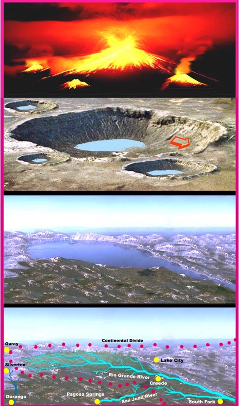
About sixty million years ago there were volcanoes blowing holes in the earth’s surface and venting huge amounts of minerals and ash. When a volcano blows it vents and leaves a large empty space in the cone, which ultimately collapses. This leaves a jagged ring of mountains around the volcano’s perimeter. One very large volcano developed and blew leaving the basic shape of the Continental Divide in this area. Other volcanoes overlapped earlier ones and a rugged landscape resulted.
Over more time, water from rain and snow filled the craters forming giant lakes. The lowest point on the edge of the crater (note arrow) became a spillway that eroded faster turning into a river. This is how the area’s major river, the Rio Grande, developed along with many other lesser waterways. Over millions of years, erosion from water, wind and the ice age left a worn down but still rugged landscape. One fifth of the peaks in the United States over 14,000 feet elevation are in this range.
Slowly, soil developed along with a variety of plant and animal life and the area took on the environment of today. Plants tend to stabilize parts of the surface but still the surface is not static. Erosion continues and one day the mountains will be gone.
In the last image the current towns are shown in their approximate locations.
