
 Timescale of the San Juan
by Norm Vance
This is a chronological history with brief historical references. For more detail see specific articles on this website.
500 MYA (Million Years Ago)
This date is an apt starting place for our time scale of the San Juan because the area was 100% different than now. At this point in time the San Juan area was a shallow ocean. The beach was up around the present Canadian border. Almost all of the earth’s land mass was composed of separate “plates” which were clumped together on the other side of the planet in a gigantic area now called Gondwanaland. The land was barren but the seas were teeming with tiny life forms. (Check Florissant Fossil Beds Northeast of Gunnison.)
200 MYA
The enormous plates moved about the planet with several forming the continents of the western hemisphere. The San Juan area is now a desert but much of the earth’s surface is lush with plant life. This is the age of the dinosaur. (Check at Dinosaur Monument northwest of Montrose.)
200 to 80 MYA
Gold & SilverDuring this time many upheavals were caused by the Pacific Plate grinding into the plate that is North America. At times vast seaways filled much of the San Juan area bringing sand and clay resulting in layers of sandstone, shale, and various other layered formations. At about 80 MYA the pressure of the plate action became too great and large fractures occurred between the present Boulder, Colorado area, across the San Juan area and toward the southwest corner of the state. These deep cracks in the surface allowed molten minerals to flow upward. They flowed into empty spaces in the broken crust and cooled to solids. 80 million years later people mined into these and removed gold, silver, and many rare minerals. The area is known as the Colorado Mineral Belt. All but one of Colorado’s famous mines is located in this ancient area.
60 MYA
new set of plate pressures start pushing on the west side of the country’s land mass causing great folding and uplifting in the earth’s surface. This formed early mountains. For the next 40 million years a quiet period of erosion took place. This erosion carried material out of the higher lands and spread it around the mountain’s edges forming deserts.
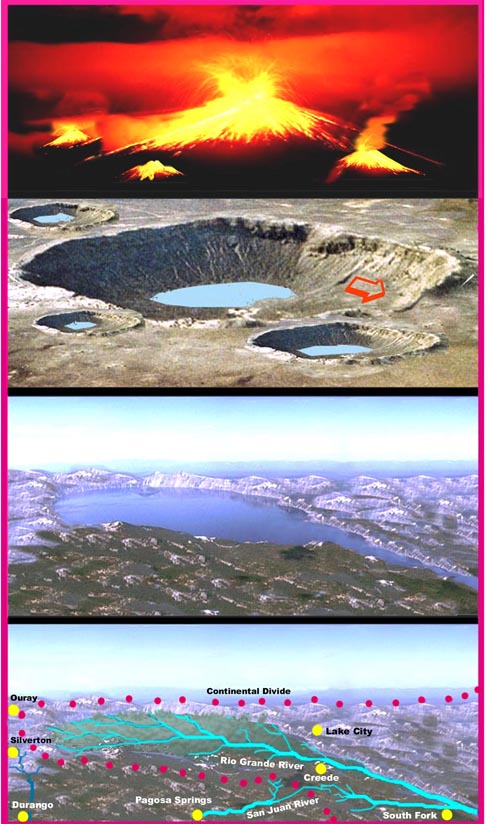
35 MYA
Boom! Starting at 35 MYA and lasting almost ten million years great volcanic explosions blew holes the San Juan area. Huge mounds of volcanic ash and magma grew into new mountains. When empty of magma and energy the huge volcanoes collapsed leaving craters. New volcanoes grew and also collapsed until the craters overlapped into a moonscape.
The great volcano activity died down about 20 MYA. This was the end of the era of earth shaking events in the San Juan area. Molten minerals still leaked into fractures, the floors of old volcanoes settled and filled in, and slowly a time of peace came to the new baby mountains.
This peace was not a still time however, just slower. There was an enormous amount of heavy rock thrown out or pushed up into a rugged landscape. Gravity acted on the more unstable rock. Rock slides and rock movement both exposed new mountain peaks and covered other vast areas.
Other events went to work carving the San Juan. These were caused by wind, water and ice. The ice age caused a build up of an ice pack on mountains and in the valleys. These glaciers moved and scoured valley walls and floors. Some valleys became wide canyons. As sections of earth were slowly pushed upwards, rivers cut deep narrow gorges. Over vast periods of time, wear and erosion cut the San Juan Mountains and valleys into the shape we find today.
Slowly winds brought in soil components. Winds, birds and animals carried seeds and the area grew a vast array of plants.
New Animals
The dinosaurs were gone by 65 million years ago. Other animals survived the early harshness of planet earth and were separated as the plates pulled the land mass apart. Great wooly mammoths, bison, early elk and deer, and a wide variety of animals had the San Juan to themselves for millions of years.
4 MYA to 30 TYA – Mankind
(Please note the time changes from millions of years ago to thousands of years ago.)
Man began and lived in what are now Africa, Asia, and Europe. The Americas were separated from the Eastern Hemisphere by the vast oceans of the world until about 30,000 to 50,000 years ago.
30 TYA
The last great Ice Age began about 60 TYA. The ice sheets took water from the oceans lowering them hundreds of feet. The ice build up projected down into the United States covering Canada completely. Higher elevation areas such as the San Juan developed glaciers which once again changed the landscape.
The Humanity Pump
Although it was the Ice Age, temperatures and weather still varied. Mankind had spread north and east in what is now Siberian Russia. Slowly, over generations, hunting tribes followed prey across the ice cap toward Alaska. The warmer times drew them north and east. Then a cooling period drove them south into Alaska and Canada. The ice age weather was a pump that pushed early man into the Americas. Given several thousand years these people populated to the southern tip of South America.
10 TYA Man Enters the San Juan
Just when the first man or tribe entered our San Juan area is unknown. Because mountain life is harsher than at lower elevation the early nomads populated the lower areas of America first. In the San Juan area early man first followed mammoth or bison up waterways higher and higher into the mountains during summer’s heat. These early people are called Paleo Indians. They are known as “The Great Hunters.” It is truly an adequate name considering they faced huge mammoths with crude stone tipped spears and clubs and hunted three quarters of the mammals to extension!
These early people lived in crude, temporary tent-like structures. Small tribes moved about an area according to the supply of food and the season. Their spears were stone tipped and these points and other stone tools are about all we know about them. All of the other material goods they possessed were organic and have long since rotted.
8TYA
The general weather and temperature patterns began a slow change, becoming warmer. This caused a movement of Indian tribes across the southwest. The early hunters followed prey east to the plains. Tribes from the west and south moved into the area living mostly in the dry deserts of New Mexico and Arizona. This is known as the desert culture and they developed into the Anasazi.
The Anasazi lived in a large area of the southwest for 2000 years developing from nomadic hunters into farmers and city builders. They moved away from the San Juan area when severe drought conditions developed toward the end of the 1200’s. They became the current Pueblo culture. A couple of centuries later the Navajo and Ute Indians moved into the mostly empty San Juan area.
400 YA Close Encounter!
Europeans began sailing to this hemisphere beginning with Columbus. Later Spanish explorers landed in Mexico and pushed north and west working their way up the Rio Grande Valley. It was a close encounter for the Pueblo, Ute and Navajo who first saw a horse mounted Spaniard. They had never seen a horse or a non Indian before.
Trade was quickly set up between the Indians and the Spanish. The Spanish wanted furs from the Indians and the Spanish needed workers to use to herd sheep. The Indians wanted the wondrous horse. They traded hides and their children to the Spanish for horses which they often killed and ate. Anger and violence began soon as the whites moved onto more Indian land and the Indians began stealing horses and cattle. The Spanish treated the Indians harshly in an effort to change evey aspect of their culture and religion.
1750 (Approximate)
White men moved into the New Mexico area which was considerably easier to travel through than the mountains to the north. The Utes traded hides gathered in the San Juan. This ultimately caused a few early Europeans to venture into the southern borders of the area.
1761
The San Juan became of great interest to the Spanish who had long expected to find civilizations in the area loaded with gold and silver. There was already the fur trade and information that traces of silver and gold had been found in the mountains to the north got their attention. The governor of New Mexico sent Juan Rivera to explore north of Santa Fe and into the mountains. He returned with still more inviting news of the high mountains.
200 YS -1776
At the same time our country’s founding fathers were preparing the Declaration of Independence for a group of states on the eastern coast, a small band of men and women set off from Santa Fe on a mission of adventure and exploration. The goal was to find a passable route from the Catholic missions in New Mexico to the newly established missions in California.
The leader of this expedition was Fryer Dominquez. It was Fryer Silvestre Escalante who recorded the activity and discoveries made. Escalante’s recordings were the first accurate descriptions of the southern San Juan. The mountains and roughness of the land caused exact locations to vary but maps were made and landmarks given names.
The terrain also was a challenge for the expedition. After skirting along the southern and western San Juan and making it to north of the Grand Canyon the expedition turned back returning to Santa Fe.
1800-1840
Following the Louisiana Purchase, President Jefferson sent several expeditions into the west. The famous Lewis and Clark group pushed across the Rocky Mountains and on to the Pacific taking a northerly route. Another group led by Zebulon Pike pushed into the San Luis Valley just east of the San Juan. This was Mexican territory and a Mexican army patrol arrested the Pike group.
Lewis and Clark, Pike, and others reported on the wild animal life in the mountains. Early trappers began working their way up the waterways into the mountains. These were powerful and strong willed men who began the “Mountain Man” legends. They not only had to face a rough natural environment but also the sometimes unfriendly Indians.
Support for trapping came from England. The English gentleman of the day simply had to have a beaver skin hat or two in his collection. This fad caused the trappers to face the harsh life. They left their names on many mountains, rivers, parks, and other landmarks.
Trading Posts
A few of these hearty mountain men began to see a need for outposts to service the trapping business. Several trading posts and military forts sprang up. A minister, Joseph Williams, left a description of a fort on the Uintah River. He attempted to “save” the mountain men who he described as “fat, dirty, idle, greasy, drunken, swearing, and unbelievably wicked.” Preacher Williams saved himself by leaving the fort. By 1840 the beaver hat fad faded and the fur market crashed ending the big fur business but leaving the San Juan investigated by white men. Many of the trading post became towns and some the cities of today.
1848
The colorful John Fremont was the next to explore the area.
Fremont had a long history of exploring and popularizing the mountains in his writings. He had problems with the army and was once court marshaled. Later, as a citizen he was hired to blaze a trail to California from St. Louis. He pushed his group into the San Juan from the east, just north of the present South Fork, Colorado. Fremont moved 120 mules and 32 men into the mountains in early winter. No mules and only 23 men made it back. Once again the San Juan turned back attempts of the white men to blaze a trail through it.
The Old Spanish Trail
The route followed by Dominguez and Escalante was traveled by others and became the historic Old Spanish Trail that ultimately linked Santa Fe with Los Angeles.
The Santa Fe Trail
In 1821 the Santa Fe Trail was opened between the east and Santa Fe. The combination of the Old Spanish and Santa Fe trails allowed new traffic into the area. The trails were used for decades by trappers, settlers, cowboys and other brave souls.
Spoils of War
In 1846-47 the United States and Mexico were at war. The United States defeated Mexico and won from Mexican rule the lands that became New Mexico, Arizona, California, Nevada, Utah and Colorado.
Pagosa became better known when in 1859, a party led by Captain John Macomb entered the area following the Old Spanish Trail. Macomb camped at and was awed by the Great Pagosa Hot Spring. He returned to the U.S. with news about his travels to the Great Pagosa and of gold deposits he had seen in Southwest Colorado rivers.
The Lure of Gold
The country was already deep into gold-fever because of the rush to California and the gold finds in Colorado west of Denver. The lure of gold in the San Juan began a rush that would forever change the area. The San Juan Mountains had been a barrier holding back exploration and settlers. Harsh winters and rugged terrain had been more than the Spanish or early Anglos wanted to deal with. Fortunes in gold was a different matter and soon after the news of streams gleaming with gold was received, the rush was on.
The area northwest of Pagosa Country saw the major gold and silver strikes. The towns of Silverton, Ouray, Tulluride, and others sprang to life overnight. At the same time Summitville, the largest mine in the Pagosa area, began production. Summitville is south of present day Wolf Creek Pass.
Pagosa with its well-traveled trails remained an access route and cross -roads. The Great Pagosa Hot Spring was well-known by travelers and miners. In the summer months of the early 1870’s the Great Pagosa Hot Spring was a welcome rest and recuperation spot.
Fort Lewis
In 1878 the U.S. Army moved to Pagosa Springs and built a fort on the bank of the San Juan River across from the Great Pagosa Hot Spring. The mostly blackmen, called “Buffalo Solders,” were there to protect miners and settlers from unhappy Indians.
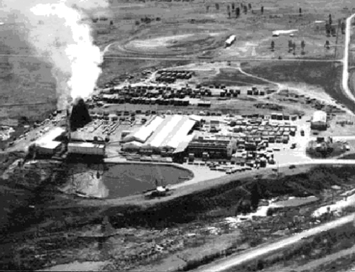
In the early 1800’s there were many sheep herders in the Pagosa area. Sheep wondered the mountains in summer and were routed to the southern foothills in winter. Intermixed with sheep were cattle and large ranches developed across the area, but lumber became the main industry of the area.
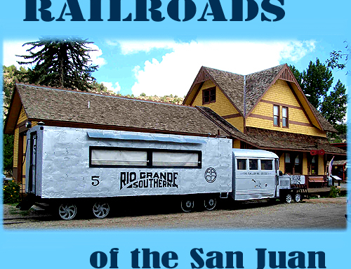
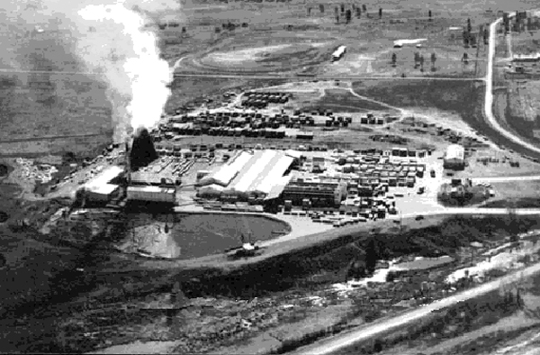
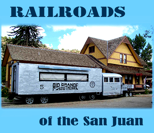
Rail Roads
The major railroad line by-passed Pagosa Springs to the south stopping at Pagosa Junction on its way from Chama to Durango. Train tracks were laid into many valleys and to Pagosa Springs. These were “spur lines” used to haul lumber and ultimately connected to the main line.
Wood from Pagosa was shipped to many diverse locations from home construction in Denver to chopsticks in Japan.
During World War I a better route from the San Luis Valley to the San Juan Valley resulted in Wolf Creek Pass being constructed.
The towns that now exist in the San Juan area are the towns that survived. Many settlements and towns began only to fade away as time passed. It is to the credit of the past residents of Pagosa Country that their courage and tenacity kept the area alive. In a harsh environment their spirit overcame the ups and downs of economy and nature.
Pagosa now has a multi-faceted economy and lifestyle. Cattle ranches still exist and the cowboy is very much a part of the area. Light industry can be found from small lumber mills to many cottage industries. Tourism and summer and winter sports are the main industry in modern times.