Treasure Mountain. Somewhere in the area around this mountain vast treasures of gold was found and lost and…
The following text Courtesy of Center of Southwest Studies,
Fort Lewis College
The Center of Southwest Studies, Fort Lewis College
Tales of lost treasures
The presence of precious metals enflamed an unquenchable thirst for striking it rich by means of a lucky discovery of silver or gold, and this dream, in turn, spawned tales about lost mines and treasures. Whether based on fact or fancy, these stories became part of the lore of mining. Generally, in whatever part of the West they occur, they share certain common elements. After a rich outcrop or float is found, by accident more often than not, an emergency arises — a snowstorm, illness, or hostile Indians — forcing the discoverer to leave. He may cache some gold if he has sufficient time. He may leave a blaze on a tree or a pile of rocks to mark the spot, sometimes even draws a map, but neither he nor later treasure seekers are ever able to relocate the exact site. Perhaps the tree has been burned or a rockslide has changed the scene. Not surprisingly, the rugged San Juan Mountain region is the setting for several of these events.
Sheepherders helped perpetuate treasure tales. With solitary weeks spent in the high country, herders had opportunities to repeat stories around their campfires, to dream of riches, and to investigate rumors they had heard. Although not the most common method of searching for treasure, one technique was somewhat like water witching, with two partners holding needles toward each other in hopes that the needles would move, indicating the location of the treasure.
This well-known treasure tale pertains to Spaniards, not Utes, but the setting is called the Old Ute Mine because it is near Ute Creek. The site is a short distance east of the Continental Divide, northwest of Pagosa Springs, in the area of La Ventana [name of an arch in Saguache County; Twin Mountains USGS map; elevation 8,927′] near Rio Grande Pyramid [13,756′ summit in Hinsdale County, Colorado]. La Ventana, “the window,” is a notch on the Continental Divide that would indicate that searchers were close to the treasure. In about 1750 or 1780, Spanish-speaking miners from Taos, who were working a mine, were attacked by Indians. The miners were killed and their skeletons were left at the entrance to the mine. In the late 1800s a French prospector began searching for the mine, and when he died in the 1930s he left a map which he had drawn. According to the stories of two Hispanic men, they stumbled upon the cache in 1919. Another story is that Candido Archuleta found the location in 1912 while he was herding sheep in El Rincon La Vaca, but he had lost a paper with the address of the person whom he should notify to assure him of the cache’s exact site. Yet another version is that two Hispanic sheepherders said they found a site with bones, but they found no cache of gold. From time to time prospectors and sheepherders came into Durango with bags of ore, which they said came from Bear Creek, not far from Ute Creek. While attempting to return to this site, others inevitably became lost.
Treasure Mountain
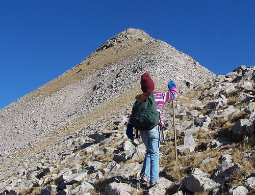
Best known among the San Juan Mountains’ tales of lost gold is Treasure Mountain, a peak located south of Wolf Creek Pass (Wolf Creek Pass USGS map; elevation 11, 758′). A large party of French explorers is said to have come there while investigating the mineral wealth of Louisiana Territory in 1791. According to one story, they found ore at Summitville, on the eastern side of the Continental Divide. That winter they went to Taos in Spain’s New Mexico, but they kept their discovery a secret. When they left the next year, they cached gold worth millions of dollars, but, returning later for it, they were attacked by Indians. The gold was reburied, and a map of the cache was made. Resorting to cannibalism, five escaped and returned to France. One of the survivors, a Le Blanc (sometimes called Le Breau), made two copies of the map, one of which was given to the French government and the other of which remained with his family who returned to Taos. There, a Bernardo Sanchez was hired to guide a large party to the site, but he returned to Taos alone, leaving the end of this story a mystery as to whether the Frenchmen might have returned home with the gold, were murdered, or met some other fate. (Le Blanc family members and copies of a map still are found in the San Luis Valley.)
Another version of the Treasure Mountain story, placing the site almost on the Continental Divide, relates that Bernardo Sanchez was hired by Don Archuleta, a pioneer of Archuleta County, to guide him to Treasure Mountain. Although Archuleta invested considerable money in this venture, no treasure is known to have been found. Other attempts followed in vain. Treasure Falls on Treasure Creek, at the western foot of Wolf Creek Pass, reminds passersby of the Treasure Mountain legend.
 Treasure Mountain
A second version from http://www.legendsofamerica.com/co-treasures8.html
In the late 1700’s a French expedition of 300 men and 450 horses journeyed from an outpost at present-day Leavenworth, Kansas on their way to the Rocky Mountains. Once they reached the mountains, they began to prospect, at first without success. Working their way south, they made camp several miles east of Wolf Creek Pass, near present-day Summitville.
Prospecting in the many creeks and streams of the area, they supposedly found a large amount of gold on Treasure Mountain. The amount of gold today would be valued at as much as $33 million dollars. The Frenchmen stored the gold in three different places and the commanding officer was in charge of the map.
When the French arrived, the Indians did not initially disturb them, but as time went on, the Indians mounted a brutal attack upon the expedition and a fevered battle ensued. Quickly, the French buried the gold and made new maps, but most of the Frenchmen were killed by the Indians. Only an estimated 17 to 35 men were able to flee the area, only to be attacked again, once they reached the Front Range. After this second brutal strike, only five weary men began the journey back to Kansas. However, winter was upon them, and starvation and bitter conditions killed three more, leaving only two who finally stumbled into the Kansas outpost. Even then, only one of the two survived. The sole survivor, a man by the name of “Le Blanc,” was the expedition’s historian. After recuperating at the outpost he made the long journey back to France, with two copies of the treasure map, one of which he gave to the French government, the other, he kept for himself.
A second expedition was mounted to retrieve the buried treasure, though it is unclear weather the mission was conveyed by La Blanc’s family or by the French government. Fifty men headed back to the Summitville area, passing through Taos, New Mexico, where they hired a guide to lead them to the area.
However, months later, the guide returned to Taos alone, claiming the entire expedition had again been wiped out by the Indians. The Taos locals were suspicious of the “sole survivor” and in the last Mexican trial held in United States territory, they tried him for murder but he was acquitted. Some theories claim the whole story was contrived by the Frenchmen, who secretly found the gold and returned to France, paying the guide to return to Taos, New Mexico with the untrue story of a massacre.
Over the years, several maps have appeared which claim to lead to the buried treasure. A man by the name of William Yule supposedly had a copy of the original and searched the entire western side of the valley, north to Saguache, without success. Later, a prospector named Asa Poor supposedly obtained the map from Yule and with two partners, was able to locate several landmarks leading to the treasure, but never found the hidden gold. One of Poor’s partners, named Montroy, retained possession of the map, but it disappeared several years later.
More recently, a local area family, who claims to be direct descendents of Le Blanc, professes to be in possession of an authentic map written in French. Supposedly, for three generations they have been quietly searching for the lost cache. After years of search, the family members claim to have located seven of the eight landmarks that are mentioned on the map.
Then, in 1993, one of the family members was hunting elk in the mountains south of Del Norte. When a cold hard rain began to fall, he took shelter in a 3-foot opening in the ground, which turned out to be a 5 by 4 foot wide man made tunnel. Exploring the tunnel, he crawled about 20 feet into the hillside, when suddenly his path was blocked by an underground landslide. Shining his flashlight around the dark passageway, he observed a carving in the rock wall, which was supposedly the long-lost eighth clue. The following day, 20 of the family members returned to the passageway to excavate the cave-in, tunneling an additional twelve feet into the mountainside. Getting late in the day, the family lined the length of the passageway with candles but before they got a chance to light them a rattlesnake lunged out of the gloom at the end of the tunnel just barely missing one of the family members.
Frantically, he scrambled back to the entrance when a swarm of bats poured out from the hillside, squeaking and diving aggressively at the surprised party. Undaunted, they knelt down to light the first candle at the entrance to the tunnel when the candle at the far end of the tunnel inexplicably flared on by itself! While the stunned group gaped at each other in horror, a huge owl dive-bombed the shocked party within inches of their heads. Terrified by these unusual events, the family fled the passageway and returned home.
Is the French gold “guarded” by an unknown entity? Something eerie happened that day. Though scared off that day, the family has since obtained the Colorado state treasure rights to legally enter the cave and claim whatever treasure may remain there.
Additional information also suggests that the Ute Indians may have acquired some of the French gold during the battle that occurred, hiding it near the mouth of the Rio Grande Canyon.
Lieutenant Stewart’s placer, also known as Kit Carson’s mine
During one of his journeys to California, Kit Carson is said to have traveled with a contingent of the U.S. Army in 1847. Lore has it that they traveled up the Rio Blanco and the San Juan River to avoid Indians and followed Turkey Creek to Four Mile Creek. While washing pots and pans, Lieutenant Stewart discovered flecks of gold in the stream and made a note of the location so that he could return after the trip to California, but he lost his notebook and, thus, the location.
Another story finds a Lieutenant Jim Stewart carrying mail to California in 1852, but Indians caused his party to take a detour up the Piedra River. Lore has it that Indians later destroyed landmarks so that the placer could not be found again.
Timber Hill
After stealing some gold bars from a smelter at Ophir, two smelter workers departed on a circuitous route to Silverton and over Stony Pass. When a burro “played out” near the eastern foot of Stony Pass, the thieves decided to bury four bars and to take one with them with the intention of returning in spring for the others. They left a blaze on a tree to identify the spot. One man was shot in a bar and the other was too busy to return until, years later, when the site was covered by a reservoir.
Lost Trail
Ore being freighted in three ore wagons over Stony Pass became part of legend. Near the Lost Trail junction, at the west end of Rio Grande Reservoir, bandits were detected. Sacks of ore from two of the wagons were hidden in a nearby marshy area before the robbers fell upon the teamsters, killed them, and made off with the third wagon. Supposedly, the robbers took this wagon to Silverton and sold the ore, and they never returned for the remainder.

