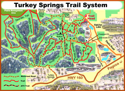
Turkey Springs Trail System in Pagosa Springs

TURKEY SPRINGS/CHRIS MOUNTAIN AREA
- Stay left on trail marked for cross-country skiing.
- Turn left at this gate. (Turn right for a quick return to Turkey Springs Road.) Watch for two really cool cabins you can rent from the Forest Service.
- This single-track is easy to miss. Look for the big log lying across the trail to left of road. Also, brown Forest Service posts mark the turn.
- Fremont Court is access to lower trails. Trail is faint until it intersects the double-track.
- Ponds. If you take your dog, be aware that these ponds all are usually dry by late July.
- Another easy to miss single-track. Look for two rock cairns on left side of road.
- Also, look for a blue Forest Service post to the left. This trail is faint in places. If you lose the trail, go north until you reach the fence. Follow the fence line east until you come to Brockover Road.There is a cattail filled pond at this intersection. Also, there is a house north of the trail.
- Loop can be ridden either way. I prefer riding counterclockwise. Turn right at
top of climb. - Don’t miss this turn. As you ride downhill into an open meadow, look for rock cairns to your left.
Terrain is generally uphill going North and West. South and East are usually downhill. Mileage shown on trail sections are from intersection to intersection and are approximate.
Forest Service road numbers are: Turkey Springs Road-629; Monument Park Road-630; Newt Jack Road-923; & Brockover Road-919.
Terrain in Turkey Springs area is generally rolling with elevations ranging from 7700 to 8075. Terrain in Chris Mountain area is steeper with longer climbs and descents. Elevation ranges from 8100 to 8850.
This map and description provided by the friendly folks at Juan’s Mountain Sports.


