Cross Country Skiing and Snowshoeing in Pagosa Springs

 The Pagosa Country area is a real paradise for Nordic or cross-country skiing and snowshoeing. Pagosa Country draws many cross-country skiers because of the remote wilderness areas available for winter recreation. Compared to more high-traffic areas, like the Front Range or the Interstate 70 corridor, the Pagosa mountains are another world altogether. A sense of quiet solitude remains with you at all times when you’re skiing through the excellent powder the area has to offer. With so much wilderness, it’s easy to explore and create new trails, and when you find that special, secret route, you’ll be awed at the isolation.
Not only is it blessed with nice snow even during most drought years, it has many trails that snowmobilers are not likely or allowed to use. Some of these are skied often enough that nice tracks are set and a couple of trails are “smoothed” by snow machines and a smoothing drag. The local snowmobile club grooms several trails that are also used for skiing/shoeing.
Visit the Nordic Club Website as well as the
Pagosa Trails Website for more details!
The Lobo Trail
This trail is located at the summit of Wolf Creek Pass, (see article Playground at the Top of the World and map). The main trail is legal for snowmobiles and is smoothed by a snow machine with a drag in an effort to take the snowmobile damage out of the trail. Most snowmobile use is snowboarders being taken to the top so this traffic is not too great.
There are alternate trails used by skiers and shoers only. One exits directly from the parking lot just behind the large sign and is easy to find. This trail is steeper and more difficult and is best used by intermediate and better skiers.
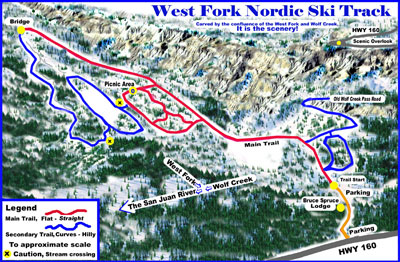
The West Fork Ski Trail
This trail is located just west of Treasure Falls on Hwy 160, east of Pagosa Springs by about a dozen miles. It is not seen from the highway so watch for the West Fork Campground and Bruce Spruce Guest Ranch signs. The road is plowed down a short hill and parking is available. In poor weather conditions two-wheel drive vehicles should be parked along the highway and skiers walk or ski down to the trailhead. There is plowed parking beside the highway.
The main trail is on the road serving three National Forest Campgrounds. Several loops are skied through the campgrounds and picnic tables and restrooms are found along these trails (bring your own paper). All of the main trail and camp loops are nice and flat and great for beginners. Past the bridge a trail goes uphill to a trailhead. Skiing beyond the trailhead is only for better skiers and avalanche conditions can be dangerous. A left turn just beyond the bridge is also for better skiers. It is a roller coaster-like trail uphill and a dead-end.
On the main trail just beyond the second camp is a sharp turn to the left. A secondary trail turns right here and is for better skiers after the first half mile. It goes along the old highway bed for a mile and is mostly uphill and a dead-end.
There is skiing in the bottom of the valley but can only be accessed when very deep snow allows skiing across the river. Be very careful when attempting to make the crossing.
Turkey Springs Play Area
A lot of skiing is done north of the Fairfield/Pagosa Lakes development in the Turkey Springs Road area. This area also gets a lot of snowmobile traffic so care must be taken. The trails follow several forest roads, as well as others at random through the trees. This is a flat area and good for beginners.
The Continental Divide is the backbone of a system of trails covering half a million acres in the Weminuche Wilderness. There is infinite back-country skiing in the area. Several local snowmobilers are regularly cutting trails through the backcountry for cross-country skiers to explore and enjoy. Many trails are broken by other skiers, and you can take advantage of their hard work if you happen to find such a trail. Don’t hesitate to be adventurous — sometimes the best trail is the one you discover for yourself. With mountains and valleys, streams and forests, its no wonder Pagosa Country is considered a cross-country skier’s paradise.
 The winter views are also excellent for the skier with camera equipment. Local amateur photographers have taken breathtaking shots of wildlife, scenery and nature from their skis. Cross-Country skiing is one excellent way to truly get back to nature on a personal level.
Even with the solitude and peace you’ll find in the snowy forests, it’s important to take along the proper supplies and equipment. Avalanche danger is very real in Pagosa Country. Check on weather conditions before leaving and consider purchasing an emergency avalanche beacon to aid rescuers should you become trapped by an avalanche. Local ski shops all offer good advice, and in some cases, maps of existing ski trails. Enjoy Pagosa Country’s fabulous winter wonderland on skis or on a snowmobile. The chance is good that you’ll remember your experience for the rest of your life.
Good skiing and remember, keep the waxed side down!
Nordic Trail Maps
All map distances in kilometers.
 |
See a larger printable map here.
Click on “printer friendly version,”
upper right corner.
 |
 |
 |
 |
||||||||||
|
a huge warming bonfire and smiles…
|


